Tropical Track & Forecast
Interactive - 5 Day Track Forecast Cone / Coastal Watches & Warnings

Coastal Watches/Warnings and 5-Day Forecast Cone for Storm Center

[columns] [column_item col=6]
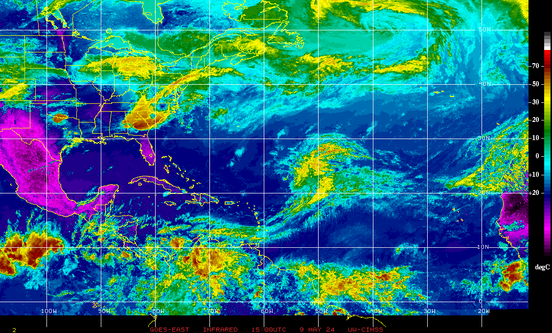
Current Infrared Satellite Image 2014 Tropical Cyclone Tracks
Atlantic Tropical Weather OutlookNational Hurricane Center - Atlantic Tropical Weather Outlook
|
Latest Tropical Weather Outlook[columns] [column_item col=6] |
|
[columns] [column_item col=6] Probability of Formation 0-24hrs
Probability of Formation 24-48hrs
|
Graphical Tropical Weather Discussion

NHC Tropical Weather Discussion (Atlantic)
National Hurricane Center - Tropical Weather Discussion (Atlantic)-
NHC Atlantic Tropical Weather Discussion
000
AXNT20 KNHC 081804
TWDAT
Tropical Weather Discussion
NWS National Hurricane Center Miami FL
1805 UTC Wed May 8 2024
Tropical Weather Discussion for North America, Central America
Gulf of Mexico, Caribbean Sea, northern sections of South
America, and Atlantic Ocean to the African coast from the
Equator to 31N. The following information is based on satellite
imagery, weather observations, radar and meteorological analysis.
Based on 1200 UTC surface analysis and satellite imagery through
1750 UTC.
...MONSOON TROUGH/ITCZ...
The monsoon trough passes through the coastal plains of Guinea-
Bissau close to 12N16W, to 06N20W. The ITCZ continues from 06N20W,
to 04N23W 05N30W 03N40W 02N45W. Precipitation: widely scattered
moderate to isolated strong is from 08N southward.
...GULF OF MEXICO...
A surface ridge passes through 28N73W in the Atlantic Ocean,
through central Florida, to the upper Texas Gulf coast. A NW-to-
SE oriented inland Mexico surface trough passes through 24N100W,
to the SW Gulf coastal waters, and it curves into southern
Guatemala. No significant deep convective precipitation is
apparent in the satellite imagery. Moderate to fresh SE winds span
the entire area. Moderate seas are in the western half of the
area. Slight seas are in the eastern half of the area. Haze
continues to restrict the visibilities in parts of the western
Gulf of Mexico, due to agricultural fires that have been in SE
Mexico.
Fresh SE winds will prevail across much of the Gulf through Thu
ahead of a cold front. The cold front will move off the Texas
coast into the northwest Gulf Thu night and will move across most
of the basin through Fri. The front will then slow down and weaken
further as extends from South Florida to Veracruz, Mexico, by
late Sat. Meanwhile, fresh to locally strong winds will pulse
nightly through late week off the northern and western Yucatan
Peninsula. Haze due to agricultural fires in southeastern Mexico
persists in the western Gulf. Patchy fog is possible along the NW
Gulf coast tonight.
...CARIBBEAN SEA...
An upper level trough is generating cyclonic wind flow between 50W
and 80W. This area includes the Atlantic Ocean and the Caribbean
Sea. Precipitation: isolated moderate to locally strong remains in
the area of the upper level cyclonic wind flow. The forecast is
form the trough to weaken gradually, and to move to the northeast
of the area through Thursday night. Abundant deep layer tropical
moisture has been remaining in the eastern Caribbean Sea. The
moisture and the ample instability should result in more
convective precipitation, some locally heavy, in the eastern
sections of the Caribbean Sea, through at least early Thursday.
Please, read advisories, bulletins, and forecast watches and
warnings, from your local weather bureau offices.
Moderate seas are nearly everywhere from 80W eastward. Some
exceptions are for slight seas in the NE quadrant of the Caribbean
Sea, and off the coast of Venezuela along 70W. Slight seas are
from 80W westward. Mostly moderate to some fresh easterly winds
span the entire Caribbean Sea.
The 24-hour rainfall totals in inches, for the period that ended
at 08/1200 UTC, are: 1.72 in San Juan in Puerto Rico; 0.13 in
Guadeloupe; and 0.01 in Freeport in the Bahamas. This information
is from the Pan American Temperature and Precipitation
Tables/MIATPTPAN.
High pressure centered just SE of Bermuda will support moderate
to fresh trade winds over the south-central and SE Caribbean into
the weekend. Meanwhile, expect pulses of fresh to locally strong E
winds at night across the Gulf of Honduras tonight through Fri
night due to the pressure gradient between the high pressure and
lower pressure over the western Gulf. Gentle to moderate winds and
moderate seas will persist elsewhere.
...ATLANTIC OCEAN...
Rough seas are from 24N northward between 35W and 50W. Moderate to
rough seas are from 24N northward between 50W and 60W. Moderate
seas are in the remainder of the Atlantic Ocean. Moderate to fresh
E to NE winds are from 25N southward from Florida eastward, on the
southern side of the large-scale anticyclonic wind flow.
A 1020 mb high pressure center is near 30N49W. Broad surface
anticyclonic wind flow is from 30W westward.
A surface trough is along 31N25W 20N35W. Precipitation: widely
scattered moderate to locally strong is from 20N northward from
40W eastward. An upper level trough is generating cyclonic wind
flow between 50W and 80W. Broken to overcast multilayered clouds,
and widely scattered moderate to isolated strong, are from 13N to
26N between 40W and 65W.
High pressure centered SE of Bermuda is supporting moderate to
fresh E winds S of 23N today. These winds will diminish tonight as
the high pressure shifts E. As a cold front approaches the US
East Coast, fresh to strong winds will develop off northeast
Florida tonight through Fri night. The front will move across
Florida late Fri night into Sat.
$$
mt/ar


 [/column_item] [column_item col=6]
 [/column_item] [/columns]
 [/column_item] [column_item col=6]
 [/column_item] [/columns]