Tropical Track & Forecast
Interactive - 5 Day Track Forecast Cone / Coastal Watches & Warnings

Coastal Watches/Warnings and 5-Day Forecast Cone for Storm Center

[columns] [column_item col=6]
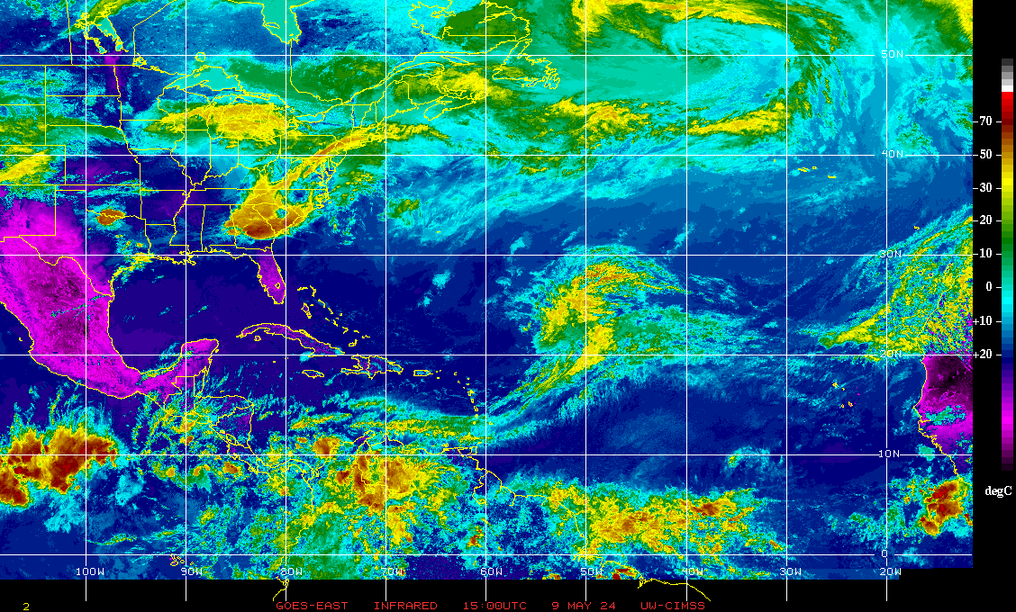
Current Infrared Satellite Image 2014 Tropical Cyclone Tracks
Atlantic Tropical Weather OutlookNational Hurricane Center - Atlantic Tropical Weather Outlook
|
Latest Tropical Weather Outlook[columns] [column_item col=6] |
|
[columns] [column_item col=6] Probability of Formation 0-24hrs
Probability of Formation 24-48hrs
|
Graphical Tropical Weather Discussion

NHC Tropical Weather Discussion (Atlantic)
National Hurricane Center - Tropical Weather Discussion (Atlantic)-
NHC Atlantic Tropical Weather Discussion
000
AXNT20 KNHC 080605
TWDAT
Tropical Weather Discussion
NWS National Hurricane Center Miami FL
0605 UTC Wed May 08 2024
Tropical Weather Discussion for North America, Central America
Gulf of Mexico, Caribbean Sea, northern sections of South
America, and Atlantic Ocean to the African coast from the
Equator to 31N. The following information is based on satellite
imagery, weather observations, radar and meteorological analysis.
Based on 0000 UTC surface analysis and satellite imagery through
0545 UTC.
...MONSOON TROUGH/ITCZ...
The majority of the monsoon trough remains inland over Africa,
and extends briefly southwestward off the west coast of Africa
to near 09N18W, where latest scatterometer data indicates the
ITCZ begins and continues to 05N24W to 03N31W to 02N39W and
02N40W to 03N44W and to the coast of Brazil near 02N50W. Scattered
moderate to isolated strong convection is seen within 120 nm north
of the ITCZ between 39W-42W. Additional scattered moderate to
isolated strong convection is well southeast of the ITCZ from
02N to 04N and east of 10W to well inland Africa. Scattered
moderate convection is within 60 nm either side of the ITCZ
between 42W-46W, and also well south of the ITCZ from the
Equator to 03N between 11W-19W.
...GULF OF MEXICO...
The Bermuda subtropical ridge extends west-southwestward to the
north-central Gulf. Recent partial ASCAT data and latest buoy
observations show light to gentle winds in the eastern Gulf,
and generally gentle to moderate southeast winds over the rest
of the basin, except for moderate to fresh east to southeast winds
over the western Gulf and Bay of the Campeche. Per latest
altimeter data and buoy observations, seas are in the 3 to 5 ft
range, except for slightly higher seas of 4 to 6 ft over the
central Gulf and lower seas of 2 to 4 ft over the NE and
southeastern Gulf areas.
Satellite imagery shows overcast mostly mid and upper-level
clouds streaming east-northeastward over the western Gulf north of
24N and west of 90W. In addition, haze due to agricultural fires
in southeastern Mexico persists in the SW and west-central Gulf
Otherwise, mostly clear skies are elsewhere across the basin.
For the forecast, low pressure extending from north-central
Mexico into the southern U.S. plains will continue to draw in
mainly fresh SE winds across much of the Gulf into Thu night.
Locally strong winds are likely to pulse nightly through late week
off the northern and western Yucatan Peninsula. Looking ahead, a
weak cold front will move off the Texas coast into the northwest
Gulf Thu night, shift southeastward and slow down and weaken
further as extends from South Florida to Veracruz, Mexico by late
Sat. The haze in the SW and west-central Gulf sections is
expected to linger into early Fri.
...CARIBBEAN SEA...
A persistent broad mid to upper-level trough is over the western
Atlantic, with its southern portion stretching southwestward into
to the north-central Caribbean. Isolated weak showers are over the
waters between eastern Cuba and Jamaica. The trough will
gradually weaken and move farther northeast of the area through
Thu night. Abundant deep-tropical moistures remains prevalent in
the eastern Caribbean. This in combination with ample instability
provided by the aforementioned trough should result in more
precipitation, some possibly locally heavy, over some sections of
that part of the sea through at least early on Thu. Presently,
scattered showers and possible isolated thunderstorms are from 14N
to 16N and east of 72W. Please see local weather advisories for
more information.
Recent ASCAT data indicates that moderate to fresh trade winds are
over the south-central Caribbean. Seas over these waters are in
the 4 to 6 ft range. The data along with a few buoy observations
reveal gentle to moderate trade winds over the rest of the basin.
Seas with these winds are 3 to 5 ft.
For the forecast, high pressure centered over the western
Atlantic will support moderate to fresh trade winds over the
south-central and SE Caribbean through late week. Meanwhile,
expect pulses of fresh to locally strong east winds mainly at
night across the Gulf of Honduras starting Wed night, between the
high pressure and lower pressure over the western Gulf. Gentle
to moderate winds and moderate seas will continue elsewhere.
...ATLANTIC OCEAN...
The SW North Atlantic continues to be under the influence of
high pressure that is anchored by a weak 1019 mb high center
analyzed southeast of Bermuda near 31N53W. The associated
gradient is allowing for moderate to fresh trade winds to exist
south of about 23N and west of 60W and from 18N to 21N between 45W
and 57W. Another weak high center, of 1017 mb, is near 29N70W. A
trough bisects the Florida peninsula from N to S. A cold front
extends from near 31N27W southwestward to 21N36W, where it becomes
a stationary front to 18N42W and a weak frontal trough from there
to near 17N55W. Broken to overcast mostly low and mid-level
clouds with embedded patches of rain and embedded showers and
isolated thunderstorms are noted within 90 nm either side of a
line from 18N42W to 17N51W and to near Guadeloupe. Overcast
multilayer clouds, with large patches of mostly moderate rain and
embedded showers and possible isolated thunderstorms are ahead of
the front north of 20N. The pressure gradient is weak over the
eastern Atlantic east of the first front.
Low-level cloud streamers in the moist easterly flow are noted
south of 25N and west of 69W. Isolated showers with some of these
clouds.
Seas of 8-10 ft due to long-period north swell are north of 26N
between 38W and 55W. Fresh to west to northwest winds are over
this area of seas. Moderate or weaker winds along with moderate
seas are elsewhere.
For the forecast west of 55W, the moderate to fresh trade winds
over the far southern waters will diminish as the ridge shifts
eastward into late week. Meanwhile, large long-period north swell
associated with low pressure well north of the region over the
north central Atlantic will propagate through the waters north of
27N and east of 60W through tonight. Looking ahead, expect fresh
SW winds off northeast Florida starting Wed night ahead of a cold
front that is expected to move off the Carolinas.
$$
Aguirre


 [/column_item] [column_item col=6]
 [/column_item] [/columns]
 [/column_item] [column_item col=6]
 [/column_item] [/columns]